Showing posts with label waterfall. Show all posts

Tuesday, 12 March 2019

Illawarra Basin Falls, (Central Coast NSW)

The Illawarra rivers meet a relatively narrow coastal plain after plunging down the coastal escarpment. While most do not run in dry times, they can put on a spectacular display after heavy rain.

The features of the area were early studied by an impressive group of early European settlers and visitors (eg Rev Clarke and the United States Exploring Expedition in the Pacific under Commander Charles Wilkes, with the famous mineralogist, James Dwight Dana). Some of the waterfalls seen by the travelers have been submerged in dams.


Monday, 5 November 2018

The Waterfalls of Cabone Benel & Caladonia Australis - Falls of East Gippsland (index)

In the south-east corner of Australia is a vast area of unexplored wilderness full of rivers and dancing waterfalls.

The First People of the Monaro, called it Cabone Benel. We are unsure what the insular Kurnai, the First People of this area, called the region. Some of the older residents remember other names, including 'Caledonia Australis' conferred by the first Scot to enter the region.

Today, officially, it is called Gippsland - a controversial name conferred by the Polish explorer Strzelecki in honor of the hard-working Governor Gipps (1836-1847), sent to an early death by rapacious squatters.

At the border of rainforest and eucalypt forests, the confluence of
the cascading McKenzie River and the dark still Bemm River

Saturday, 3 November 2018

Molonglo Gorge Cascades, Canberra, ACT

The Molonglo River flows slowly over an ancient sandstone plain until it hits the Molonglo Gorge.

Lower Cascades, Molonglo Gorge


This gorge hosts 50 small waterfalls and cascades, through a Bull Oak Forest (Red Stringybark, Black Cypress Pines, and Bull Oak Casuarina).


Molonglo Gorge

Carrington Falls, Budderoo National Park, Robertson, NSW

The Kangaroo River falls 50m (150') into the Upper Kangaroo Valley over a sandstone escarpment.


In Australia, even waterfalls burn in the summer heat. A couple of years ago Carrington Falls on the Kangaroo River burnt. As of the time of writing, it is still dangerous to venture into the area (the waterfall still works, but fire makes the tall trees and the rock cliffs unstable).  


Friday, 26 October 2018

Jerrara Falls, Bungonia National Park

A long ribbon waterfall which can retreat into the rock face in dry periods. Notes: In a deep canyon, the Jerrara Creek fall through a series of cascades (200m, 600') on its way to the Shoalhaven River. This is the final fall (80m, 240') in the cascade. The trees at the base are retained to give a sense of the fall.
The falls are signposted from Adams Walk in the Bungonia State Conservation Park. At the Ranger's Station, stop and check the maps. There are other splendid walks in the area,
Jerrara Falls


Monday, 22 October 2018

Valley of the Waters, near the town of Wentworth Falls, Blue Mountains, NSW

While the descent into the Valley of the Waters is challenging (and, in wet or icy conditions, dangerous), those who take the hike are never the same. It is said that those who survive live longer, smile harder and speak slower. 


base, Empress Falls


Monday, 1 October 2018

Australian Waterfalls and Cascades

Waterfalls of South Eastern Australia


There are 15,000 waterfalls, cascades and races in SE Australia. This base of information looks at those which are reasonably accessible.

INTRODUCTION

Each waterfall is unique

Tianjara Falls: deep in the Budawang wilderness 


Each has its own shape, sound, vibration, memories

Carrington Falls: images dance in the veil and rocks


Each has its own mysteries and risks 

Minyon Falls, a high rainforest beauty 


Hear them shape the world

Little Crystal Creek Falls, warmth in the mountain cool 


Come explore them with me

INDEX

New South Wales

Bargo Canyon, Narregarang, Hill Top
Belmore Falls, near Robertson, Morton National Park
Bridal Veil Falls, near Leura, Blue Mountains National Park
Carrington Falls, near Robertson, Budderoo National Park
Cascade Fall, Macquarie Pass National Park
Cave Creek Canyon, Hill Top
Currambene Creek Falls, The Falls Picnic Reserve
Dance Floor Cave Veil, Kanangra-Boyd
Demeter Falls, Burragorang Falls, Kanangra-Boyd NP
Empress Falls, Valley of the Waters, Blue Mountains National Park
Fairy Bower Falls, Side Falls, Top Cascades, Main Plunge, near Bundanoon, Morton National Park
Fairy Falls, near North Lawson, Blue Mountains National Park
Federal Falls, near Orange, Mount Canobolas State Conservation Area
Fitzroy Falls, near Moss Vale, Morton National Park
Flat Rock Falls, Valley of the Waters, Blue Mountains National Park
Frederica Falls, near North Lawson, Blue Mountains National Park
Govetts Leap (Bridal Veil Falls), near Blackheath, Blue Mountains National Park
Gordon Fall, Blue Mountains
Granite Falls, Morton NP
Grotto Falls, Yarrunga Creek Falls, Morton National Park
Grove Creek Falls, Abercrombie Karst Reserve
Hazel Falls Track, Hazelbrook
(Hazel Fall Track inc Burgess, Oaklands, Horseshoe, Lena, Glow Worm Nook, Fairy)
Horseshoe Falls, near Blackheath, Blue Mountains National Park
Jenolan River Cascades, Jenolan Karst Conservation Reserve
Jerrara Falls, near Bungonia, Bungonia National Park
Kalang Falls, Burragorang Falls, Kanangra-Boyd NP
Kanangra Falls, 🐉 Burragorang Falls, Kanangra-Boyd NP
Katoomba Cascades and Falls, near Katoomba, Blue Mountains National Park
Koorawatha Falls, near Young, Koorawatha Park
Lady Hordern Falls, 🐉 Yarrunga Creek Falls, Morton National Park
Leura Cascades, near Leura, Blue Mountains National Park
Lodore Falls, Valley of the Waters, Blue Mountains National Park
Macquarie Rivulett, Macquarie Pass NP
Majors Creek Falls, Majors Creek State Conservation Area
Mares Forest Creek Canyon 🐉, Wombeyan Karst Reserve
Minnamurra Waterfalls, Blue Mountains NP
Minyon Falls , near Nimbin, Nightcap National Park
Molonglo Gorge Cascades, Canberra
Mumbulla Cascades, Biamanga National Park
Myanba Gorge, Coolangubra Forests
Nalbaugh Falls, Coolangubra Forests
Narregarang Falls, Bargo Canyon, Hill Top
National Falls , Royal National Park
Nellies Glen, near Robertson, Budderoo National Park
Paddy's River Falls, Tumbarumba
Parma Creek Falls, The Falls Picnic Reserve
Rainbow Fall, Macquarie Pass National Park
Rockton Falls, Genoa River,
Sawpit Creek Fall Australian Alps,
Silver Cascades, Grose Valley
St Michaels Falls, near North Lawson, Blue Mountains National Park
Sylvia Falls, Valley of the Waters, Blue Mountains National Park
Thurat Walls, 🐉 Burragorang Falls, Kanangra-Boyd NP
Tianjara Falls, Morton National Park
Tuross Falls, Wadbilliga National Park
Twin Falls, 🐉 Yarrunga Creek Falls, Morton National Park
Valley of the Waters 🐉, Blue Mountains National Park
Wadbilliga Cascades (Tuross Cascades), Wadbilliga National Park
Wandandian Falls (Granite Falls), Morton National Park
Wentworth Falls, near the town of Wentworth Falls, Blue Mountains National Park
Yandyguinula Cascades, near Queanbeyan

Australian Capital Territory

Gibraltar Falls, Namadgi National Park
Kangaroo Creek Falls, Namadgi National Park
Molonglo Gorge Cascades, Canberra, ACT
Mountain Creek Cascades, Tidbinbilla, Canberra, ACT
Paddys River Cascades, Tidbinbilla, ACT
Uriarra Cascades, Canberra, ACT

Victoria

Genoa 1/9 (Rockton, Hopping Joe, Genoa Gorge, Genoa Creek Falls)
Cann 2/9 (Winnots, Beehive, Fiddlers Green, Neville, Upper Cann, Lower Cann) Beehive Creek Falls
The Bemm (tba)
The Snowy
- Upper (Buckleys, Byadbo, Jacobs, Pinch, Little River, Wulgulmerang)
- Middle (Basin, Raymonds, Spring, Cabbage Tree, Falls Creek, Young) Basin Creek Falls
- Lower (Youngs, Little Cabbage, Falls Creek, Devils Hole)
Tambo (tba)
Nicholson (tba)
Mitchel (tba)
Erskine Falls, Great Ocean Road, Victoria

Queensland

Little Crystal Creek Cascades, Paluma, North Queensland


Background notes


For a while now I have been photographing Australian waterfalls of all sizes and complexities. 2016 was particularly wet, recharging a lot of the highland springs and marshes that feed some of the higher falls. This turned some of the falls into raging torrents. In contrast 2018 was dry, and the falls fell silent for long periods.

I am slowly building this web resource of location details and images for each of the accessible waterfalls. Recently I worked out that on average it takes me about 75 minutes to drive to a parking spot, and then about 50 minutes to walk to each fall, and another 60 minutes playing with it: swimming in the pools if safe to cool off, photographing if the light and flow is ok. So each fall takes about 5 hours to capture. Some waterfalls can be hard to find; of the last 10 falls i went looking for, i only found 6 in my allotted time. But i had a good time.

I take a well padded bag - it gets knocked around a lot. It carries 2 Cannon bodies (1 waterproof), CPL filters (to increase/reduce water surface reflection) and ND filters (to darken the lens and allow long exposure shots). I will take a combo 1000mm lens if i am not going to get next to the fall but otherwise carry a simple all purpose zoom and wide angle lens for normal use. You would be mad to bring high end lenses down into canyons or into the wet environments around falls. Finally I pack 2 tripods - a sturdy all purpose machine and a tiny flexible one i can stick into crevices while i hang onto a rope.

I make sure my hands are free while hiking, take high quality hiking boots, a sturdy walking stick (three legs are better than two), plenty of water and a small medical kit. I take a smart phone with mapping coordinates downloaded (still does not help with most waterfalls) knowing that in the bush I will not get cell reception but i will get some GPS positioning away from canyon walls. I take a times-two recharge battery for the phone, a backup compass and paper map and a fold-away solar recharger. If i am going in a long way, i take an emergency flare.

The below is an indicative list of the waterfalls i am imaging at present. I have pictures of some, but am taking a little time to revisit and get accurate height and better mapping information about each location. Some of these are in inaccessible areas without road access, some only flow when access is impossible.

Kanangra Boyd NP

Barralliers (~150m) (Kanangra Boyd NP)
Barrier (Doris Creek) (~150m) (Kanangra Boyd NP)
Bernard Grotto (Kanangra Boyd NP)
Box Creek Falls, Box Creek, upstream junction Kowmung River
Christys Creek
Higgins (~150m) (Kanangra Boyd NP)
Johnston, Wheengee Whungee Creek (Shamash Deep)
Margaret Falls (~150m) (Kanangra Boyd NP)
Whalania Falls, Whalania Creek, upstream junction Sally Camp Creek
Wheengee Whungee (Kanangra Boyd NP)

Blue Mountains NP

Beachamp Falls, Grand Canyon, Blue Mountains, NSW
Millnigang (~150m) (Millnigang Creek, near Wombeyan)
Mumdebah Falls, Jigger Gully
Queens Cascades

Central West (Orange/Cowra)

Beaumont (~50m) Falls, Orange, NSW
Black Flat Creek (~50m) (Canobolas)
Bong Bong (~40m) (near Cowra)
Gully Creek (~50m) (Canobolas)

Comboyne

Bona Vista Falls (~80m) (near Comboyne)
Bridal Veil Falls (~150m) (near Comboyne)
Deep Gorge Falls (~50m) (near Comboyne)
Diamond Falls (~20m) (near Comboyne)
Ellenborough (~120m) (Ellenborough River) (near Comboyne)
Rawson Falls (~50m) (near Comboyne)

Morton NP (inc Budawangs)

Bundundah (~20m) (Bundundah Creek north of Sassafras)
Coal Mine (~50m) (Bundanoon Creek near Bundanoon)
Crooked (~100m) (Angel Creek) (Budawang NP)
Dungeon (~100m) (Shoalhaven River, near Marulen)
Gerringong (150m+) (near Robertson)
Munnuldi (~150m) (Budawangs)
Murrumbooie Falls, (Budawangs)
Ngadyoo Falls, (Budawangs), Sth NSW (Porter's Creek, near Porters Creek Dam, Little Forest Plateau)
Ngaityung Falls, (Budawangs), Sth NSW (Pigeon House Creek, near Cradle Swamp, Little Forest Plateau)
Perryman (~100m) (Ettrema Creek north of Sassafras)
Sluice Box (~100m) (Budawang NP)
Sparkles (~50m) (near Shoalhaven River, Marulen)
Talntrerany Mountain Falls, Budawangs, Sth NSW
Trawalla Falls, Budawangs, Sth NSW
William (~80m) (Bundundah Creek north of Sassafras)

Newcastle

Abbots (~5m) (Manning River, near Taree)
Apsley (~25m) (Apsley River, near Walcha)
Deans Creek
Dilgry (~100m) (Dilgry River, near Thunderbolts Lookout, Scone)
Lower Hastings (~60m) (Hastings River, near Beechwood)
Tia (~50m) (Tia River, near Walcha)
Upper Hastings (~100m) (Hastings River, near Beechwood)

ACT (and nearby NSW)

Bogong Creek Falls, ACT
Coree Creek Falls, ACT
Corrowong (~60m) (near Snowy River, Delegate)
Dubbo (~80m) (Goobarragandra River, near Tumut)
Falls Creek (Princes Highway at the Jervis Bay)
Ginini Falls, ACT
Ginninderra (50m+) (near Belconnen)
Landers Falls 10km 3hr Talbingo Snowy Mtns Hwy
Mountain Creek Falls, (Cavan), NSW
Pierces Creek Falls, ACT
Sawyers Gully Billabong, (Cavan), NSW
Stockyard Creek Falls, ACT

Dorigo/Armidale

Dangars (~150m) (Salisbury Waters near Armidale)
Ebor (50m) (Guy Fawkes River, near Armidale)
Mihi (~150m) (Salisbury Waters near Armidale)
Wollomombi (~200m) (Wollomombi River near Armidale)

North Coast

Belgrave (~5m) (Macleay River, near Kempsey)
Boonoo Boonoo falls and cascades (~200m) (near Stanthorpe)
Gibberagee State Forest Waterfall
Undercliffe (~150m) (Bookookoorara Creek, near Stanthorpe)

Sydney

Arabanoo Creek ?

Ungrouped

Morung Falls, Morung Creek (near Morung Deep)
North Overshot (~20m) (Morphetts Creek, near Broken Hill)
Two falls off the Bullock Track, near Mt Lofty, South Australia (thanks to Steve for the tip off)
Roaring Meg Falls, Daintree, Queensland , this one off the Cleb Track, a pretty challenging road. (thanks to Steve for the tip off)


Reference Books

Go see my book Wild Waterfalls of South Eastern Australia https://www.amazon.com/dp/B079VRXB9T .


Author: Peter Quinton


You can adventure with me at my website

The books we wrote here are now on Amazon

You can find my footprints on GoogleMaps

Tuesday, 27 June 2017

Rainbow Fall

Clover Hill Road provides access to the Falls Walking Track in the Macquarie Pass National Park. There are small cascades along the Road, and the Track gives high views of the Macquarie Rivulet until it meets the creek at Rainbow Falls. Upstream there are a series of other waterfalls.

Rocks near the fall are slippery and some are fragile. Exercise extreme care.


Majors Creek Falls

Majors Creek Falls can be found in the Majors Creek State Conservation Area.

This area is not signposted and should be approached with a great deal of care.

The Majors Creek fall is a short walk from the town of Majors Creek. It races down a precipitous drop into the Araluen Valley. In total the creek's falls dance 240 m (790 feet) to the valley floor below. Only 15-20 meters of the main race from a chute fall is visible from adjoining cliff edges. Above the fall are a series of pretty pools and cascades.

While this fall was once well known (and is still well loved by the locals), the lookout for the fall is in ruins and the area is quietly fading back into the wilderness.

Majors Creek Falls

Monday, 23 January 2017

Horseshoe Falls

An intermittent plunge waterfall off the sandstone escarpments into the Grose Valley, near Blackheath, NSW (note that there are a couple of falls named Horseshoe, including those at Hazelbrook). 

This is best observed in winter/early spring after rain.


Notes: Poorly signposted at Govett's Leap at Blackheath, NSW. Take time to read the signs to the left of the Govett's Leap observation point. You are looking for the "Loop Trail" to Pulpit Rock.

The track to this point (in 2017) was via the Loop Trail down the opposite cliff face of the canyon. The trail is dangerous, overgrown in places, and washed out in a number of places. Along the trail there are a number of marked and unmarked exits, one leading to a viewing platform (keep on the Loop Trail). Like most waterfalls, there is no cell reception. The path had a number of brown snakes on it and while shy, they are blindingly fast when they heat up. While this may look an easy walk, do not attempt this without proper hiking equipment, water and crepe bandages.

This waterfall has a small catchment and will stop flowing on the surface in the summer heat, which regularly exceeds 38 degrees C (100 degrees F) out of the shade.
Within the shade of the rainforest the cicadas and birds are noisy loud. The temperature is about 10 degrees cooler, but still hot and oppressively humid.

Images:
In mid summer the falls may stop running, on the surface.

Tuesday, 27 December 2016

Basin Creek Falls, Snowy River National Park

This is a cascade waterfall in the Snowy River National Park. The waterfall is best seen from canoe from the Snowy River itself. A gravel road and walking trail will take you to the cliff edge, from which you may not be able to make out the waterfall, but with amazing views of the Snowy River below.

Access
Road access is difficult and very confusing, complicated by the lack of telecommunications facilities. If you are planning to drive here, get a detailed map. Do not rely on road signage. Access is via the Buchan-Orbost Road near the locality of Wilsons Cave. Follow Basin Road and turn onto Old Basin Road until you come to a confusing 5-way intersection. Ignore the Balley Hooly Roads and the Westlea Road at this junction and instead continue along the indistinct steep Old Basin Road which at this point quickly becomes a dangerous single-lane cliff-edge drive alongside the Snowy River. The drive terminates in a very small car park with signage to a track (a strenuous walk) that will take you to the falls. At the cliff edge there is a sign that points at the falls. Exercise great care at this point.
Avoid the area when it rains. You will not see the falls, because all the mountain you are standing on becomes a waterfall.

Images

Koorawatha Falls, Bang Bang Creek, NSW

A confluence of waterfalls and a deep plunge pool on the Bang Bang Creek near Young.
Notes: Near the cherry orchard district of Young, this is accessed through a poorly maintained bush track with a basic weather shelter that lies in ruin. The track to the falls is fairly self evident, but will require a scramble in places.
The track to these falls is strictly 4WD with deep ruts and sloping road surfaces. After rain (the best time to see this western waterfall in action) the road is impassable. Park by the side of the creek just before the weir and enjoy the 20 minute walk along the dam to the confluence of the waterfalls and the plunge pool.

Images:


Monday, 21 November 2016

Gibraltar Falls - Namadgi National Park

This is a cascade waterfall on the Gibraltar Creek. Cascades extend above and below the falls past the creek's intersection with Paddy's River. The main cascade has a 50m drop. It is in the Namadgi National Park. There are upper and lower cascades associated with the main cascade, and a small weir near the top of the falls.

Notes: Near Canberra close to the Corin Road. This is the largest and most accessible waterfall in the territory. It consists of a series of cascade with one large drop. It has a permanent flow and hosts plants and animal communities not found elsewhere.  Bogong moths over-summer here before descending like a blanket for a couple of days each year over the nearby city of Canberra and the Western mountain ranges.
Nearby are Corins Dam and the smaller and much more difficult to find Kangaroo Creek Falls.

Images:

Main Cascade


Wednesday, 26 October 2016

Frederica Falls

This fall in the North Lawson Park, Blue Mountains, NSW is split by a fire trail. The top cascade is small, while the lower falls into a deeper pool. In summer the pool is not sufficient for swimming, but the fall can still provide relief after the long walk down here. 

There are two paths from a parking bay to these falls. Only the left hand side track is obvious, and it takes you on a relatively indirect tramp that leads to the firetrail and eventually the waterfall. Check the clearing to the right for the more direct track.

Top cascade

St Michael's Falls

A cascade fall
Notes: One of a series of falls in the North Lawson Park, Blue Mountains, NSW. This is further down the path from Fairy Falls. This fall is some distance down the escarpment. The path is very steep in places.


Fairy Falls

One of a series of falls in the North Lawson Park, Blue Mountains, NSW.
Notes: This fall is the most easily accessed and is remarkable for the 'dancing fairy' in the fall, caused by sunlight hitting the flow of water (when the fall has a decent flow).
Follow the signs to the falls in the west of the car park.


Fairy Bower Falls - top of fall and cascades

Description: The top of falls and cascades are dealt with in this post. The stream itself has a number of distinct features, including the main plungeassociated falls and the top of the fall.
Notes: Access is from the nearby town of Bundanoon and the Morton National Park (Bundanoon Loop Road). The walks in the park are well signposted. The Fairy Bower Walking Track will take you down to the top of the falls (avoid the temptation to take a side path to the picnic area - this is a very long train away from the waterfall). After visiting the top of the fall, the trail will take you via a circuitous route to the base of the fall, through a breathtaking cliff face walk.
The top of the falls is a lot of fun to get too, but you should be cautious on wet steps. The top of the falls has been shaped, but the cascades above the top are beautiful. You will not get a clear view of the waterfall itself.


Friday, 7 October 2016

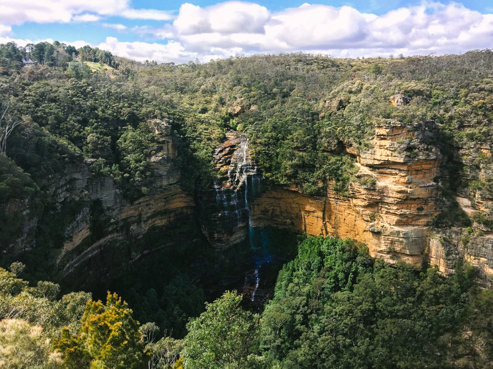
Wentworth Falls, near the town of Wentworth Falls, Blue Mountains, NSW

A cascade/plunge waterfall 185m (610') over a sandstone escarpment in the Blue Mountains.
Notes: For many Australians, particularly those living in Sydney, the Wentworth Falls is one of the first waterfalls they will experience, as they motor through the Blue Mountains to the west of Sydney. For many who stop at the top of the falls, this is bound to be a little disappointing, as they only ever see the cascades right at the top of the falls, and they miss the drop.
Near the town of Wentworth Falls, this is well signposted, and features a number of well-maintained lookouts and (dangerous) walks, including walks to the base of the falls and the falls.


The drop over the sandstone escarpment makes this one of the finest Australian waterfalls, and these days there are a number of vantage points within a relatively easy walk to get a good view of the waterfall and the cascades above and below. High wind, shadows, and low water flows can be problematic.

The escarpment at this point is sometimes referred to as the Den Fenella (although this name is formally applied to the creek that cuts the escarpment a little to the west). Den Fenella, was named after a powerful Scottish witch, the lady Fenella (the grandmother of Macbeth). Some of the early settlers came from the cold places in North Britain. The name was given by a lonely Scot who felt her magic here. The story of Fenella is told below.

In summer, the drop is alive with the sound of cicadas or smell of bush fires. In winter you may get an occasional snowflake. All around is the magic of the past, and the great Australian artist Norman Lindsay lived on a farm a few miles from here.